Auction: 15040 - Antique Maps sale during the International Exhibition
Lot: 189
Maps
Atlantic Ocean
St. Helena
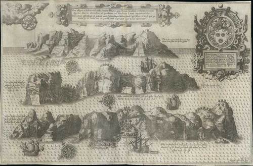
1596 "Vera effiies et delineatio Insulae Sancta Helena, qua Ortum Occasum, et Septentrionem spectat, ... " by Ioannes Hugo a Linschoten; 18¾ x 12¼ inches, uncoloured.
An incredibly decorative engraving of St. Helena on paper. Three elevations provide perspective of the rugged topography. The ocean contains several Portuguese ships. The sheet is then richly embellished with three beautiful compass roses, two elaborate cartouches and angel holding armillary sphere. Beautifully engraved by Baptista a Doetechum.
Light folding creases from insertion in the original book and paper reinforcement down central fold; in remarkable condition. Photo
This is Linschoten's second map of St Helena island in the south Atlantic. St Helena was an important re-supply point for the Portuguese starting from their earliest attempts, in the late 1400s, at rounding the Cape of Good Hope and discovering a sea route to the Indies. The island's later history included being Napoleon's final place of imprisonment, after his defeat at Waterloo.
The map shows three detailed views of the island: the town, landing places, etc. This was done as a guide to show how the island looked as approached from the sea; a compass rose below each view provides sailing directions. The safe harbour was on the northern side of the island. A ship in the harbour in bottom view flies the Portuguese standard. Text in Latin and in Dutch.
Jan Huygen van Linschoten (1562-1611) was employed as Secretary to the Portuguese Archbishop of Goa in India from 1583. Here, he had access to many Portuguese portolans as well as other valuable commercial information. Linschoten returned to Holland in 1592 and there wrote a history of his years of travel, the Itinerario..., which incorporated all that he had learned from the Portuguese. This book and the accompanying maps provided precise information on the Portuguese sea routes to the East, their re-supply points around Africa, and their trading stations in the East. The book had a tremendous influence on Dutch expansion in the East and particularly in Java.
Estimate
SG$500 to SG$600


