Auction: 15040 - Antique Maps sale during the International Exhibition
Lot: 157
Maps
Middle East
Arabia
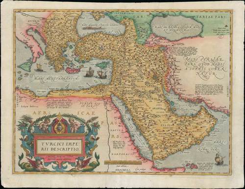
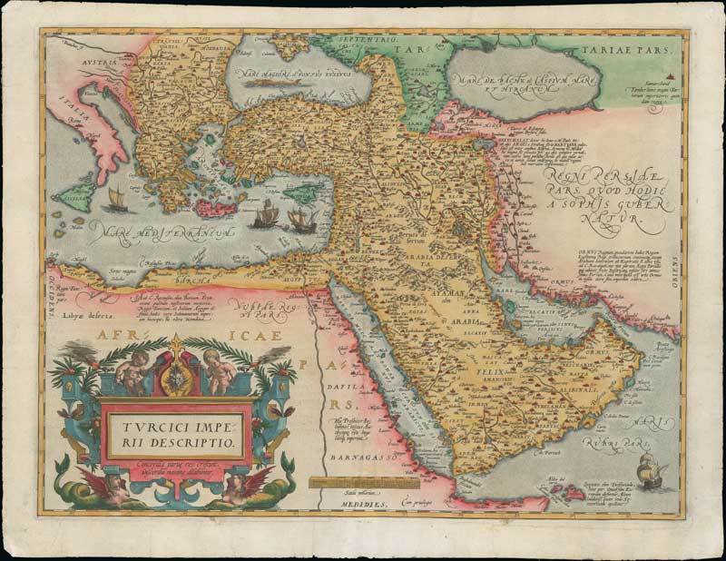
1595 Turcici imperii descriptio, this map was published in Antwerp as part of the Latin edition of "Theatrum Orbis Terrarum"; 21½ x 16¾ inches, hand-coloured.
The map is based on Ortelius' own map of Asia, which was derived from the work of Italian mapmaker Giacomo Gastaldi of 1561. There is Latin text on verso for "Turquie". It shows a relatively accurate depiction of the Red Sea but a misshapen Persian Gulf and Caspian Sea. While the coastline of the Arabian Peninsula is shown with great detail, many of the inland place names and their locations are taken from antiquity and legend rather than actual reports of exploration. The map is loaded with detail, showing mountains chains, and river systems, as well as numerous villages and important cities, such as Rome, Tripoli, Athens, Constantinople, Cairo, Jerusalem, and Mecca. Decorative elements within the map include four sailing ships (two of which are engaged in battle), a sea monster roaming the Black Sea and a strapwork title cartouche supported by two female, winged sea creatures.
The central fold has been reinforced, light overall ageing and occasional trivial peripheral damage on the edges. Photo
Estimate
SG$2,000 to SG$2,500

Watch, listen and bid as if you were in the room. Now available for auctions worldwide.
Click here to bid live
An exclusive and confidential service for the discerning collector or vendor.
View the Gallery
Download every Spink catalogue on your iPad, iPod or iPhone using free Spink app.
Download From iTunes© 2026 Spink & Son. All rights reserved.