Auction: 15040 - Antique Maps sale during the International Exhibition
Lot: 32
Maps
China
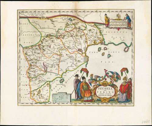
1655 Pechili sive Peking Imperii Sinarum Provincia Prima, by Johannes Blaeu; 19¼ x 15½ inches with border trimmed to about three inches, old coloured.
Copper engraving on stout wove paper. From "Novus Atlas Sinensis a Martino Martinio Soc. Iesu Descriptus ...," Amsterdam. This map includes the cities of Xvntien (Peking), Paoting and others and it is interesting to note that Tiencin (Tientsin) is a small fortification and includes the coastline of the Gulf of Chihili. Two elaborate cartouches; the scale features two astronomers with globe, the title with important dignitaries and two phoenix.
Reinforced central fold with some light soiling at top. Photo
Volume XI of Blaeu's superb atlas is the first western atlas of Asia. This volume is based on the remarkably accurate compilations of the Jesuit Father Martino Martini during his travels between 1643 and 1650. On his return trip to Rome, Martini's ship was blown off course, forcing him to land in Norway. He subsequently made a stop in Amsterdam where he met Johannes Blaeu, and agreed to assist in the production of the "Atlas Sinensis". Martini succeeded in producing very accurate maps of Japan, China, and their provinces, which may be attributed to Martini's skill as well as access to Chinese maps during his travels. His maps were copied extensively for the next century. Of particular note, in Imperii Sinarum and Iaponia Regnum, Korea is shown as a peninsula for the first time on a map produced outside of China. The Jesuit missions are indicated throughout the maps by a cross above the letters "IHS." The atlas includes a general map of China, fifteen maps of individual Chinese provinces
Estimate
SG$6,000 to SG$8,000


