Auction: 15040 - Antique Maps sale during the International Exhibition
Lot: 31
Maps
China
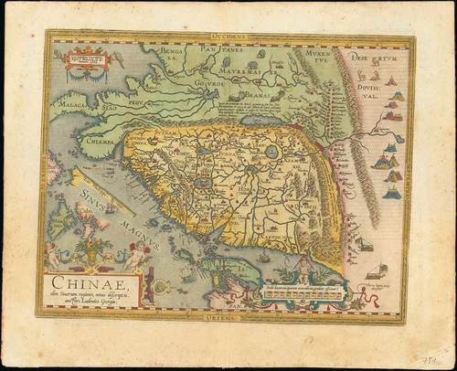
1589 Chinae, olim Sinarum regionis, nova descriptio auctore Ludovico Georgio, by Abraham Ortelius; 23 x 18½ inches, old coloured.
This is the second or third state of this map taken from the first western map of China and first published in Ortelius "Theatrum" in 1584. Based on reports of the Portuguese map maker Luis de Baruda.
With its three lushly designed cartouches and many illustrations of indigenous shelters, modes of transportation and animals, this is one of Ortelius’s richest engravings. Spanish text on verso.
Some light tone spotting in the margins. In very fine condition. Photo
Ortelius' map of China is taken directly from reports of the Portuguese mapmaker Luis Jorge de Barbuda (Ludovicus Georgius) who made a manuscript map of China which reached Ortelius via Arias Montanus. First published in 1584, Ortelius' map of China is the earliest printed map to focus on China and the first to illustrate the Great Wall of China. Tooley referred to the map as the standard map of the interior of China for over sixty years.
When this map appeared, it was by far the most accurate representation of China to appear on a printed map. Japan is shown on a curious curved projection reminiscent of Poruguese charts of the period with Honshu dissected along the line of Lake Biwa. The Great Wall is shown, but only a relatively small section, its length is significantly underestimated. The Tartar "yurts" are dotted across the plains and steppes of Central and East Asia.
The Portuguese Jesuits established a mission in China in 1577. Although the map’s Portuguese maker, Barbuda, was himself not a Jesuit, his sources for the map were Portuguese Jesuits. The Chinese characters found in the text on the verso of the map were the first introduction to Chinese language for many educated Europeans of the time.
Estimate
SG$10,000 to SG$12,000


