Auction: CSS59 - 2020 Special Collectable Sale
Lot: 259
Map
China
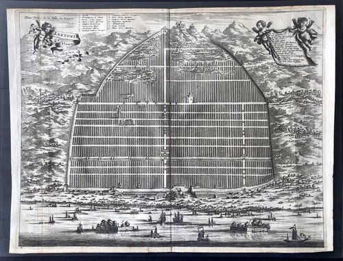
ca. 1750, a very early map of Canton, measures 39x29cm, wood block printing, map legend in French, an interesting rendition of Canton as a prosperous city with its structures built in organised rectangular blocks within its walls. At the foreground appears to be heavy maritime traffic, and numerous vessels are docked at commercial ports. This offers an interesting insight on the Western perception and impression of China, especially that of France at the time.
約1750年最早的廣州地圖,尺寸為39x29cm,雕版印刷,法語圖列。廣州被描繪為一座繁榮的都市,城墻内的建築物均井井有條地排列成數多個長方形,遠方可見建於山上的塔及要塞,近景的海岸邊有數多艘帆船於商業港口停泊,海上交通也非常繁忙。這為當時西方,特別是法國,對中國的看法及印象提供了有趣的見解。
Estimate
Starting price
HK$16000


Watch, listen and bid as if you were in the room. Now available for auctions worldwide.
Click here to bid live
An exclusive and confidential service for the discerning collector or vendor.
View the Gallery
Download every Spink catalogue on your iPad, iPod or iPhone using free Spink app.
Download From iTunes© 2026 Spink & Son. All rights reserved.